Description
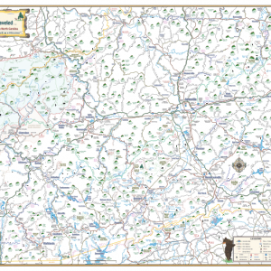
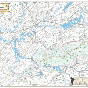
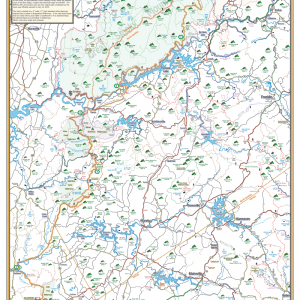
Our North East Georgia map is detailed, drawn to scale and easy to read. It includes main highways, backroads and short cuts throughout the region. Mountain peaks are also included, with elevations clearly listed including Springer Mountain (3782 ft.) which is the start of both the Appalachian Trail and the Benton MacKaye Trail.
Towns and Communities
Georgia
- Blairsville
- Blue Ridge
- Clarksville
- Clayton
- Cleveland
- Dahlonega
- Dillard
- Ellijay
- Helen
- Hiawassee
- Jasper
- Lake Burton
- Mountain City
- Sautee
- Suches
- Toccoa
- Young Harris
North Carolina
- Andrews
- Brasstown
- Franklin
- Hayesville
- Highlands
- Murphy
South Carolina
- Long Creek
Tennessee
- Copperhill
- Ducktown
- Turtletown
Outdoor Adventures & Places of Interest
- Campgrounds
- Fishing spots
- Golf courses
- Hiking trails
- Lakes
- Restaurants
- Rivers
- State parks
- Unique shopping spots
- Waterfalls
- Whitewater rafting
- Wineries
And hundreds of other little known gems in the region
Hiking Trails
- Appalachian Trail
- Bartram Trail
- Benton MacKaye Trail
- The Rim Trail at Fires Creek
- And more!
Waterfalls
- Amicalola Falls
- Anna Ruby Falls
- Bearden Falls
- Becky Branch Falls
- Big Laurel Falls
- Black Falls
- Blue Hole Falls
- Brasstown Falls
- Bridal Veil Falls
- Cochran Falls
- Desoto Falls
- Dicks Creek Falls
- Dry Falls
- Duke’s Creek Falls
- Fall Branch Falls
- Fall Creek Falls
- Glen Falls
- Helton Creek Falls
- Hemlock Falls
- High Shoals Falls
- Holcomb Creek Falls
- Horse Trough Falls
- Long Creek Falls
- Minnehaha Falls
- Oppossum Creek Falls
- Panther Falls
- Raven Cliff Falls
- Riley Moore Falls
- Rufus Morgan Falls
- Sea Creek Falls
- Tallulah Falls
- And more!
Creeks, Lakes, and Rivers
- Cartecay River
- Carters Lake
- Chatooga River
- Chattahoochee River
- Chestatee River
- Clear Creek
- Cullasaja River
- Davidson Creek
- Deep Creek
- Ellijay River
- Etowah River
- Hiwassee Lake
- Hiwassee River
- Lake Blue Ridge
- Lake Burton
- Lake Chatuge
- Lake Rabun
- Nantahala Lake
- Nottely Lake
- Nottely River
- Ocoee River
- Seed Lake
- Soque River
- Tennessee River
- Toccoa River
- And more!
Wilderness Areas
- Cohutta Wilderness
- Cooper Creek Wilderness Area
- Fires Creek Wilderness Area
- And others
Fishing Spots
All the fishing spots on the map are classified as “Heavily Stocked” and highlighted in pink.