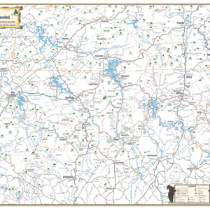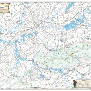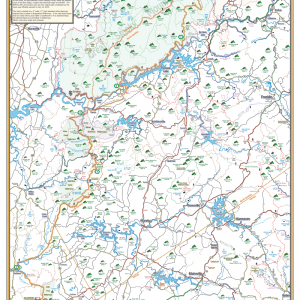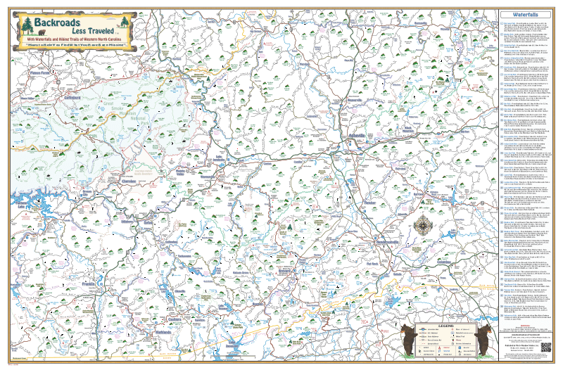
Description
Our Western North Carolina map is uniquely detailed, drawn to scale and easy to read. All maps include main highways, backroads and short cuts throughout the region. Mountain peaks are also included, with elevations clearly listed. Make a trip to Mount Mitchell, the highest peak in the eastern United States.
You will also find a good portion of the Great Smoky Mountain National Park on the map, which includes its own region of natural getaways, such as: Waterfalls, Hiking Trails (including the famous Appalachian Trail, the Benton MacKaye Trail and many more amazingly beautiful trails) and the Cataloochee Valley on the eastern end of the Park where a large number of Elk have been re-introduced into the region and are surviving well as their population expands.
Towns and Communities
North Carolina
- Asheville
- Bat Cave
- Black Mountain
- Brevard
- Bryson City
- Burnsville
- Canton
- Cashiers
- Cherokee
- Columbus
- Cullowhee
- Dillsboro
- Flat Rock
- Fletcher
- Franklin
- Hendersonville
- Highlands
- Hot Springs
- Lake Junaluska
- Lake Lure
- Lake Toxaway
- Maggie Valley
- Marshall
- Murphy
- Old Fort
- Saluda
- Sapphire
- Sylva
- Tryon
- Waynesville
- Weaverville
Tennessee
- Gatlinburg
- Pigeon Forge
Outdoor Adventures & Places of Interest
- Campgrounds
- Equestrian trails
- Fishing spots
- Rivers
- Golf courses
- Hiking trails
- Lakes
- Restaurants
- State Parks
- Unique shopping spots
- Waterfalls
- White water rafting
- And more!
Parks, Hiking Trails & Other Areas of Interest
- Mount Mitchell State Park (the Highest Peak in the Eastern US at 6684 ft.)
- Dupont State Forest (waterfalls, hiking and biking trails)
- Harmon Den Wildlife Management Area
- Laurel Mountain Backcountry Area
- Green River Game Lands and Trails
- Panthertown Backcountry Area
- Caesars Head State Park
- Cradle of Forestry
- Roy Taylor ATV Trails
- Appalachian Trail
- The Benton MacKaye Trail
Waterfalls
- Big Laurel Falls
- Bradley Falls
- Bridal Falls
- Bust Your Butt Falls
- Cashiers Sliding Rock Falls
- Courthouse Falls
- Cove Creek Falls
- Cullasaja Falls
- Daniel Ridge Falls
- Drift Falls
- Dry Falls
- Glen Falls
- Grotto Falls
- Hen Wallow Falls
- High Falls
- Horsepasture Falls
- Indian Creek Falls
- Jones Gap Falls
- Juneywhank Falls
- Kiesee Falls
- Laurel Falls
- Looking Glass Falls
- Lower Whitewater Falls
- Mingo Falls
- Mooney Falls
- Mouse Creek Falls
- Rainbow Falls
- Rufus Morgan Falls
- Setrock Creek Falls
- Silver Run Falls
- Slick Rock Falls
- Sliding Rock Falls
- Stairway Falls
- Tom’s Branch Falls
- Toxaway Falls
- Turtleback Falls
- Twin Falls
- Whitewater Falls
- Yellowstone Falls
- And more!
Creeks, Lakes, and Rivers
- Bear Creek Lake
- French Broad River
- Glenville Lake
- Green River
- Lake Adger
- Lake Fontana
- Lake Jocassee
- Lake Junaluska
- Lake Logan
- Lake Lure
- Lake Summit
- Lake Toxaway
- Little Tennessee River
- North Saluda Lake
- Pigeon River
- Tuckasegee River
- Waterville Lake
- Wolf Creek Lake
Plus many of the area’s creeks and streams
Please note: Hatchery Supported Rivers and Streams have been highlighted in pink to help anglers identify where the trout are heavily stocked throughout the region.